Thursday, April 16, 2015

Santa Cruz

This was the first time I've ever paddleboarded at Santa Cruz. The Santa Cruz Marina is a big inlet that stretches for a mile inland from the ocean with tons of boats moored on both sides. (It looks a lot like a river in Florida.)

We rented SUPs at  Kayak Connection, which was a great shop located right by the bridge that runs over the Marina on Murray Street. There was paid parking between the shop and the docks, as well as free street parking. We found a spot right in front of the shop.

After renting boards, and putting on wetsuits (provided by the shop) we walked down to the shop's dock which is about a quarter mile away. The dock is locked, so you'd need to find another place to launch if you want to use your own board.

Since it was Thursday morning, there wasn't much boat traffic in the marina but there were lots of seals and sea lions. We paddled away from the ocean to the end of the marina, then turned around and paddled back.

The Santa Cruz lighthouse is on your right where the marina joins the open ocean. The waves are breaking so you need to stay left as you paddle out. It can be a little hairy but once you pass the lighthouse the waves calm a little bit, but you will still feel the swell of the open ocean and you can see the whole bay and the Boardwalk. We had to go down on our knees and were thankful for our farmer john wetsuits.

Ann and I were a little intimidated by the open water (sharks!) especially when we saw fins. But they turned out to be a pod of eight dolphins that swam across the bay about 100 feet away.

My takeaway about Santa Cruz - the marina itself is kind of boring. The open ocean is wonderful if the weather is calm and you are not afriad.


Unfortunately I pressed the wrong button on my camera and all of my dolphin photos came out in black and white.


Wednesday, April 15, 2015

Richardson's Bay

The new SeaTrek location is at the Bay Model. There's plenty of parking and easy bathrooms. The only downside is that it's a Sea Trek dock, so if you want to launch your own board, you should probably go back to the beach where they used to be located.

If you make a left out of Sea Trek, it's not quite a mile to get to the houseboats, where you can paddle and explore, out of the wind and currents. There are some really beautiful boats along the way. It's also easy at this point to cross over to the other side of the bay, or you can paddle up to the bridge.

You shouldn't head across the bay to Belvedere right out of  Sea Trek without first checking the wind and currents. It's farther than it looks to get across (a mile) and can be hard to get back in certain conditions.

The best part about today's paddle was the baby seals. Especially the one who popped up out of the water next to his mother - about five feet from my board - and watched me together. Then he got on his mom's back to ride away.


Wednesday, March 25, 2015

San Rafael


Today I paddled out of 101 Boardsports in San Rafael. I was surprised that you could paddle from practically the center of San Rafael. You get off of 101 at 4th Street and then head east. Within a half a mile you'll pass Whole Foods and then 101 Boardsports will be on the right.
It's a great shop, with a wide variety of boards, located right on San Rafael Creek. The creek looks like a canal in Florida, with houses and apartments all along, and boats parked out back. It's a mile down the creek to get to the Bay. When I went the tide was out and the water was extremely shallow. Unless I was right in the middle of the boat channel, my fin was just a few inches from hitting the ground. I saw a couple of motorboats that were

You hit the bay north of the Richmond San Rafael Bridge and can see San Quentin as well as the Carquinos Bridge in the distance. There are a couple of islands near the boat channel — it's a six mile paddle to go from the shop, around them and back.

It's not as pretty as Richardson's Bay, but makes an interesting and fun alternative for Bay Area paddling. It's also a great place to demo new boards.


Saturday, August 9, 2014

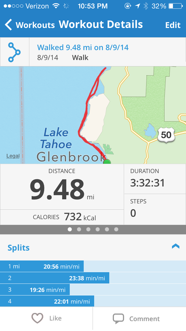
Glenbrook to Secret Harbor

This was the last paddle to complete the lake, one of the longest, and one of the most beautiful!  Unfortunately there's no easy way to get into the lake between Sand Harbor and Cave Rock, but it's too far for me to paddle on my own. So I called Gail and Ed Condren, who used to live in our neighborhood and they graciously agreed to let us in. I picked up Jenn at 6:40 in Alpine and we were on the water by 8. It was cold and breezy when we started, but happily the wind died and didn't pick up until later.


Ed and Gail's house is the one in the middle. They are standing on the balcony waving to us as we paddle out of Glenbrook.


Headed north. Beautiful coastline, no roads, no houses, nothing!  Not even any boats. Only a couple of kayaks pulled up in a cove, a couple of stray tents and a couple of fisherman (who pulled an 18 inch fish out of the lake - the first fish I've ever seen in Tahoe).


After you round Deadman Point past Glenbrook, there's a long flat point with beautiful rocks and an osprey nest. After a mile or so, you reach Skunk Harbor - and a few boats camped out. 


Finally, we reached Secret Harbor and saw the houses at Whale Beach! This is me as I complete the lake. Now time to paddle back.


We had a few waterskiers on the way back. The wind started to pick up as we hit mile 8. Here's the view looking south as we're almost done. Glenbrook is just around the corner to the left.


Glenbrook Beach.Very tired!!

The details....


Friday, August 1, 2014

Cave Rock to Glenbrook

Cave Rock first place after Sand Harbor on the east shore to put in a paddleboard - about 13 miles away. It's really a boat ramp with a small little beach on the south end where you can launch a paddleboard or kayak. There's a parking lot and a bathroom, and not much else.

It opens at 6am and I got there very early to do my paddle. I was alone for this leg but I had to paddle south for about half a mile to link up with where Jenn and I turned around going north from Zephyr Cove. There were a couple kayaks out, but otherwise it was deserted. The water is so shallow that I was worried about hitting rocks on the way south.

I turned back up north and paddled back by the rock - which was a little creepy, very shadowy - and then headed north. It was a gorgeous turquoise paddle with shallow water and a few houses and lots of empty land. The only downside is that there you can hear the road for most of the paddle.

I passed Logan Shoals with a lot of beautiful rocks and turned into Glenbrook Bay before turning around. Altogether it was 7.9 miles in 2:32.


from southward turnaround point back to Cave Rock


Logan Shoals area


 Looking back south from Glenbrook, Cave Rock in the distance

The details:


Friday, July 25, 2014

Nevada Beach to Connolly Beach

Who knew South Shore was so gorgeous? Nevada Beach is really beautiful. It's a big, deserty beach with lots of trees. We would never drive past Sand Harbor - or Bliss or Baldwin - to go there, but still I was pretty blown away by how pretty it is. I went mid-week and it was fairly deserted (expect, apparently, for the person that stole my flip flops while I was out) but I hear that it is crazy busy on the weekend.

The paddle was gorgeous. South Lake is so shallow this year that everything is turquoise. I went south from Nevada Beach to link up at Connelly with what I'd paddled from the Keys. I expected it to be like Atlantic City but there is the huge Nevada Beach, then a lovely golf course, then some low key private homes (not over the top at all). There are a few places - like where the Tahoe Queen goes out - that are a bit touristy, but otherwise very few boats and actually a very nice paddle. Nevada Beach is very easy to go out of, with a shortish walk from the car, bathrooms, wood platform for drying board, etc.

Looking north toward the point at Round Hill Pines


Looking south at Heavenly


Beach area


The details